Research
Weather and Climate Risk
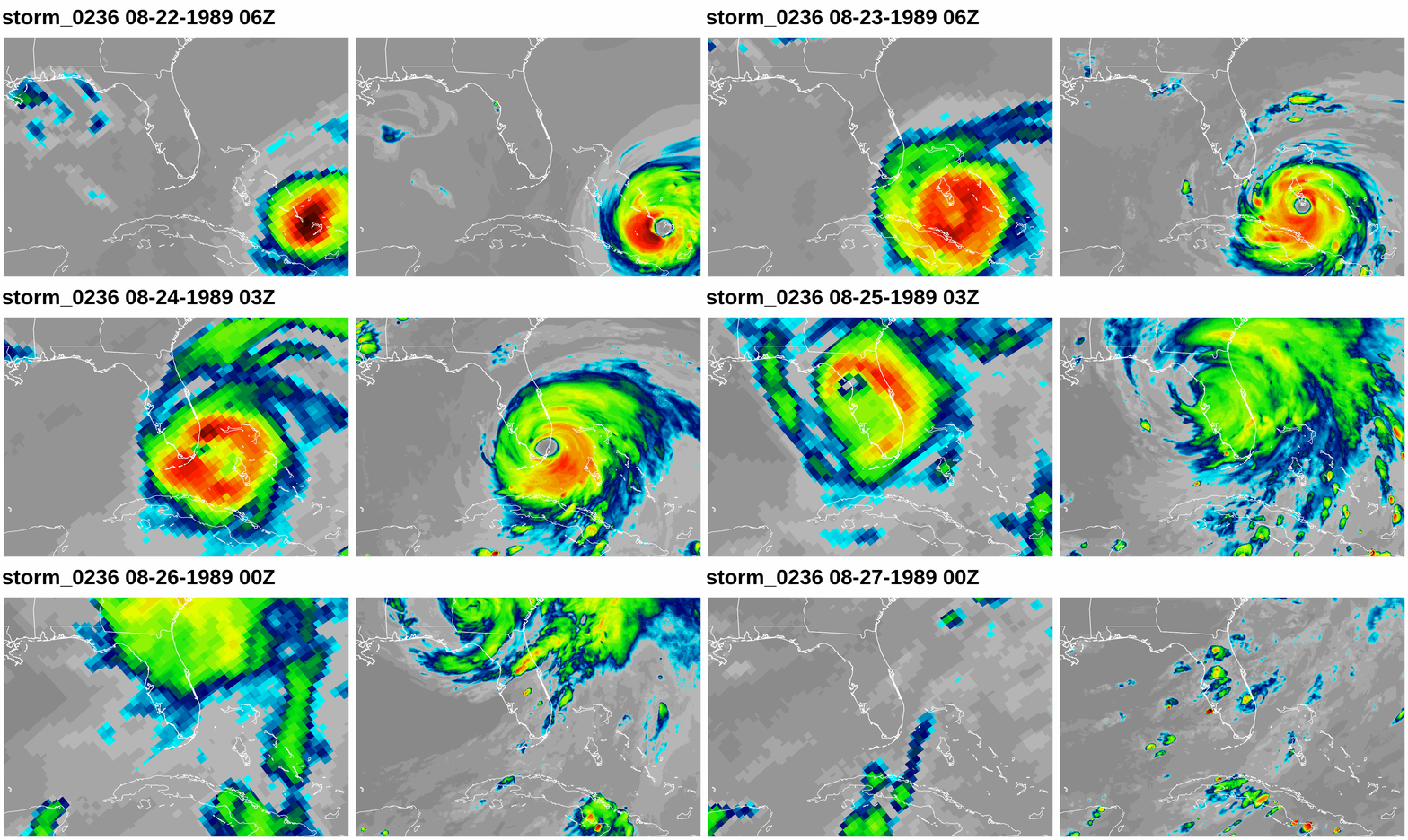 Weather and climate extremes — tropical cyclones, winter storms, atmospheric rivers, freezing rain events, and rain-on-snow floods — pose disproportionate risk to health, infrastructure, and economic welfare. Understanding and quantifying this risk requires both high-resolution physical simulation of these phenomena and frameworks that connect model output to real-world impacts.
Our work uses climate and weather models to understand how extreme event risk is changing and what drives that change. How will the frequency and intensity of landfalling tropical cyclones evolve under future warming? What determines whether a winter precipitation event becomes a damaging flood? Can storyline approaches — recreating past events under altered climates — communicate risk to stakeholders more effectively than traditional probabilistic projections?
(Pictured: Landfalling hurricane (outgoing longwave radiation) as simulated by the Community Atmosphere Model at 28km grid spacing (left) and 3km grid spacing (right). The storm is "synthetic" in that it doesn't have a historical analog was freely generated as a "gray swan" storm -- a plausible cyclone not realized in the historical record. Figure from MEWAC student Corrine Deciampa, generated with UXarray.)
AI/ML in weather and climate
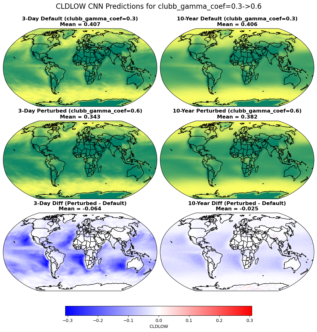 Machine learning and artificial intelligence (ML/AI) offer tools that our group leverages for connecting weather and climate across scales. Unsupervised clustering techniques such as self-organizing maps (SOMs) can identify dominant large-scale atmospheric circulation patterns and link them to the frequency and character of regional extreme events. This helps us bridge the gap between planetary-scale dynamics and local impacts in ways that traditional statistical methods struggle to capture.
Beyond pattern analysis, AI and ML are increasingly valuable for complementing and accelerating physics-based climate modeling. We have explored how neural network emulators can reproduce expensive model components at a fraction of the computational cost, enabling more rapid model calibration and better understanding of what factors govern predictions across timescales. Complementing physics-based modeling (see below), data-driven downscaling approaches use ML to translate coarse global model output into the high-resolution information needed to assess extremes at local scales, providing a practical path to actionable climate risk information without the full cost of high-resolution dynamical simulation.
Our group also places strong emphasis on the data science infrastructure that makes these applications possible, building carefully curated, AI-ready climate datasets with rigorous labeling, metadata standards, and compression strategies that make large model archives tractable for ML training and accessible to the broader research community.
(Pictured: Example of using a convolutional neural net (CNN) emulator to predict the response of simulated low cloud fraction in the Community Atmosphere Model (CAM) to parameter perturbations in a high-order turbulence scheme for short deterministic "forecast-like" runs (left) and long free-running coupled runs (right). From MEWAC student Grace Liu.)
Objective detection of weather extremes in climate data
 One area contributing to uncertainty in understanding the role of atmospheric extremes within the climate system (and their simulated future changes) is the multitude of automated detection algorithms used to find and track storms in model data. For example, the combination of the under-resolution of tropical cyclones in traditional climate models in addition to the relatively low number of storms per year (approximately 90 globally) makes quantifying the number of cyclones in a given model simulation difficult. Storm counts are sensitive to choices in threshold parameters such as surface pressure minimum, warm core anomaly, and wind speed. Ongoing research seeks to understand the uncertainty in these calculations and provide more unified algorithms for the climate community. This framework is not only tropical cyclone specific, but is extendable to the detection of wintertime storms, mesoscale convective systems, atmospheric rivers, heat waves, droughts, and other climate extremes. Current detection methods are also handicapped by 'big data.' As grid spacings grow finer and models increase in complexity, the burden of processing output grows larger due to computational limitations exposed by colossal quantities of information. Some of our work aims to eliminate this bottleneck.
(Pictured: Schematic of an extratropical snowstorm tracking algorithm. The algorithm first tracks local minima in the sea level pressure field and then integrates snowfall associated with the cyclone before categorizing the storm with a northeastern U.S. Regional Snowfall Index (RSI) value. From Zarzycki, 2018, GRL.
Next-generation global weather and climate models
 Simulating the global atmosphere at high spatial resolution is computationally burdensome and inhibits the use of these models for either fine-scale or long-term analysis of weather and climate. To alleviate these issues, limited area models (or regional climate models) have become popular, although they suffer from issues such as lack of conservation properties, mathematically (or physically) inconsistent lateral boundary conditions, and additional biases "adopted" from coarser driving models. Variable-resolution models can serve to bridge this gap, providing spatial "targeting" of computing resources to a specific region or feature of interest while maintaining a unified modeling framework. Variable-resolution models are central to both the strategic plans of the Department of Energy and National Science Foundation and are a required capability of the next generation global forecast system for the National Centers for Environmental Prediction.
(Pictured: a grid from the Community Earth System Model (CESM) with regional refinement over the eastern two-thirds of the continental United States.)
Tropical cyclone dynamics
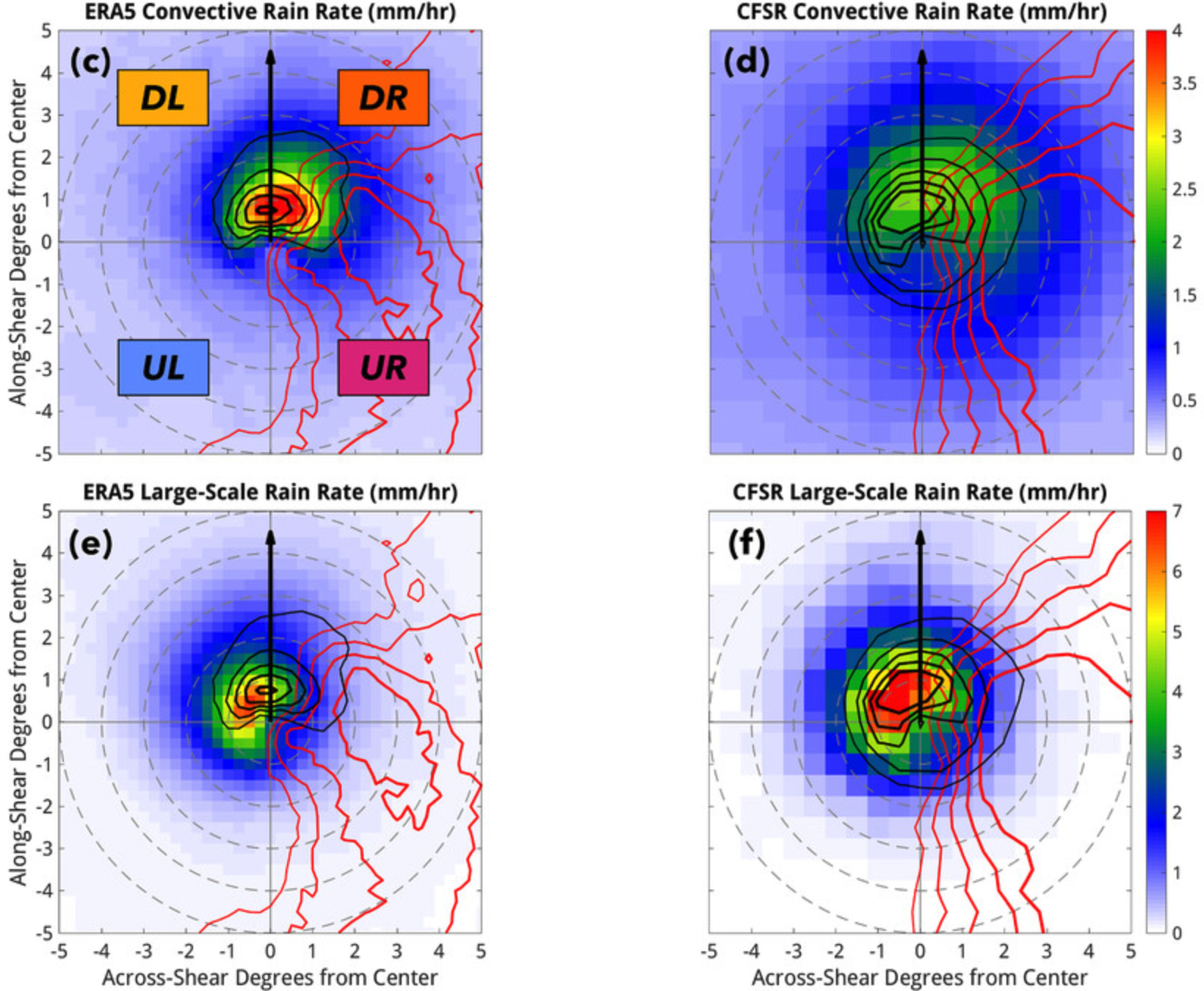 Tropical cyclones are (very) complex dynamical systems. Our group investigates what is physically happening inside a storm: how the boundary layer mediates surface fluxes and intensification, how environmental vertical wind shear organizes asymmetries in rainfall and circulation, how eyewall and rainband dynamics evolve across a storm's lifetime, and what controls the wind and thermodynamic profiles that ultimately determine a cyclone's intensity and structure. Understanding these internal dynamics is linked to understanding how TCs interact with the broader climate system, exchanging moisture, heat, and momentum with the tropics, responding to sea surface temperature and ocean coupling, and undergoing structural transitions as storms move into the midlatitudes. We are always looking to connect the fine-scale physics of the storm core to its role as a major player in the global circulation.
(Pictured: How different hurricane rain rates (convective and large-scale) are represented in two different reanalysis products in a shear relative framework. CAPE anomalies (red) and 900mb convergence (black) are contoured. From MEWAC postdoctoral researcher Jake Carstens.)
Subseasonal to Seasonal (S2S) prediction
 While numerical weather prediction has historically been focused on lead times out to seven to ten days, information regarding projected weather conditions on the scales of weeks to months is beneficial for many stakeholders. Our group pursues S2S prediction through a combination of physics-based modeling and data analysis techniques, using computationally-scalable, variable-resolution models to extend forecast integration times and expand ensemble sizes, while also applying statistical and machine learning approaches to identify sources of predictability and extract skill from large model ensembles and data archives. Advances in these areas may provide tangible benefit for energy projections, agriculture and water resource planning, and disaster risk reduction.
(Pictured: Estimate of the current state of forecast skill as a function of lead time. S2S forecasting is shown in orange. Courtesy of Columbia IRI.)
Aerosols and climate forcing
 The impact of aerosols (short-lived forcers) on climate impacts remains poorly constrained. For example, absorbing aerosols (such as black carbon) can have dramatically different heating impacts based on their spatial location in the atmosphere. Black carbon above highly reflective (high albedo) surfaces (such as snow and ice) can have nearly double the amount of forcing (per unit mass) due to incident shortwave radiation not only coming from above, but also below. This same behavior holds true for aerosols that can be lofted above highly reflective clouds. Additional work in terms of both modeling and observations are needed to reduce the uncertainty in how aerosols are emitted, where they move in the atmosphere, and how they are removed.
(Pictured: A schematic demonstrating how aerosols that absorb shortwave radiation (such as black carbon) can have a significantly larger direct radiative forcing if lofted above reflective clouds. Based on Zarzycki and Bond, 2010, GRL.)